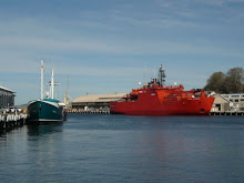
It’s been a busy month and a half since my last post. The return of daylight has prompted plenty of activity both on and off station, buoyed also by the realisation that we are now less than three months from going home. It seems amazing that the first summer ship is only a little over one month away. That ship, Voyage 1, will mark the official end of winter for us and will bring new supplies, mail, and of course the summer crew.
As I’ve been told all year, Spring is the best time for getting out and about. It’s been a sharp rise from the 2hr days we had at the dead of winter, and in just a few days we will be getting more sunlight than Sydney, for example. For all those who ask “so how long are the days now?”, at the Vernal Equinox (21st of September) everyone on the planet will be getting 12hrs of day and 12hrs of night. However from there we will be gaining almost 10 minutes a day, while Sydney will gain only three.
 Now, mid September, we are finally starting to get some nice summer-like weather too. We’ve currently been some 9 days without a blizzard or gale force winds, and none forecast for at least another few days, which is something we haven’t experienced for literally months! The photos above and below are taken of a phenomina called parhelion, or sundogs, where light is reflected off ice crystals (precipitation falling from high cloud in extremely cold weather) giving a sort of a rainbow effect.
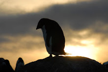
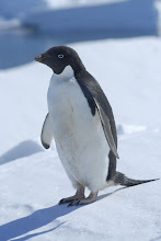
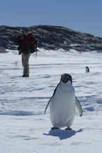
 Another reason to be out and about is the gradual return of the wildlife. For the past month I have been hearing the odd bird call here and there, and a few weeks ago some of us saw a large bird (probably a Cape Petrel) flying a little way off. However, more importantly, we are all anxiously awaiting the return of the knee-less army of black and white clowns: the Adele Penguins. Apparently they began arriving just a week or so before we got here last year (at the end of October), and since they are such curious creatures of habit we more or less know, with some degree of certainty, when they will again begin to arrive, accurate to within a day or two.
The return of life is something everyone is looking forward to, and one of the hardest things we live without here. Two or three months ago, during a week of particularly strong winds, I remember how amazed I was to see a patch of green moss that had been uncovered as the snow and ice was blown away. It was nice to see some real colour, and some life other than our own.
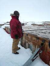
 Here you can see Bob and Curly peering into a seal hole. There was one in this hole actually, but it disappeared before I got to it with the camera… honestly.
Post mid-winter, after prolonged periods of little to no sun, and long spells of very cold temperatures (we’ve had in the minus thirties a few times), the ice in the bays around Casey become thick enough for us to start thinking about travelling on. Newcomb Bay, to the north of Casey, never really keeps ice in it for a long period of time. It is an open bay, and the absence of a substantial island mass in its mouth means that any strong wind (primarily katabatic, which always come from the east, off the plateau) will blow the ice clean out to sea. Hence we do not travel on Newcomb Bay across to Wilkes, but rather the safer land-ice route.
However there are several bays to the south of Casey, which hold the sea-ice very well. There are two bays between Casey (on the Bailey Peninsula) and Robbos Hut (on the Robinson Ridge Peninsula), and a further long sweeping bay to the south of Robbos, between it and Browning Hut (on the Browning Peninsula). These bays hold the sea-ice well due to large groups of islands at their mouths.  The ice is very flat, much like the plateau, and travelling between the huts on these bays cuts both time and distance considerably, but instead of 700m of ice beneath you, there is just one - a concept which can be very un-nerving at times, since on certain sections you can be more than 2kms from any land mass.
  Before sea-ice travel is approved though, the ice must be drilled and tested for depth. The rules are that the ice must be at least 20cm for walking on, 40cm for quad travel, and 60cm for a hagglunds – but at Casey we aim for >1m for quads, and simply don’t take haggs on the ice… there’s no way I’m getting in a hagg that’s going on the ice anyway! With all this in mind we began our sea-ice drilling and testing in late July and on the longest and most exciting of such trips I was lucky enough to be one of the four drillers.
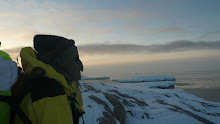
 Late one afternoon at the end of July Wayne, Bob, Curly and I set off on the jolly of all jollies: a sea-ice drilling trip for the bays south of Casey. We stayed overnight at Robbos and headed south early the next morning to drill the huge expanse of Penny Bay.
 As luck would have it we managed to pick a rare 2-day weather window of light winds and clear skies. These are conditions synonymous with very cold temps (it was around –25C), but there’s nothing like a really crisp and cold day here – everything seems to turn to crystal, including one's breath.
 As you can see we set off on quads, towing a trailer with a small generator and electric drill. One thing I’ve learnt is that tradies don’t like to muck around with the old fashioned manual labour when there is an alternative. Sounds like a cop-out, but I can tell you it would’ve taken a heck of a lot longer drilling 15kms or so at 100-200m spacing with a hand-drill in –25 degrees!
 My token working shot!
 Once the ice has been drilled a length of weighted string is passed down the hole and the depth measured. For the record we didn’t take any measurements of less than 1m, you’ll be happy to know.

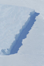
 We saw some interesting formations on the ice, such as this, where infant sea-ice (just a few cms thick) had cracked and drifted slight apart before more ice was formed below and the crack was seized open.
  Also stuck in the ice were many small and some large bergs such as this one. You don’t want to get too close really because surrounding big bergs like this the ice looks very unstable, probably due to tidal activity and the general movement of the berg itself in the winds and currents.
After drilling for most of the day (probably only 6 hours of sun-up at this point) we finally reached the Browning Peninsula and the last true field hut I was yet to visit. There is still the Peterson Mellon – which I’ve since visited – but it isn’t exactly a “hut” as such.
 Browning is situated among by far the most spectacular scenery of our region. It is an island like ridge of rock, jutting out from beyond the huge expanse of ice that looms behind it, and is sieged on either side by two vast glaciers: Peterson and Vanerford. Browning is also characterised by some of the steepest and highest terrain in the region, and after scaling one or two peaks (such as they are) I realised that that sense of vertical differentiation is another thing we are deprived of here.
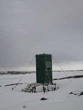
  But if we are spoilt for scenery at Browning Ridge, Browning Hut loo could be the single greatest anti-climax of the year. It has been tacked on to the hut as an apparent afterthought, blizzes up terribly, has a door that doesn’t quite shut, and doesn’t have any windows to speak of, far less a view. A contender for my “Toilets of the World” competition it is not!
  Lucky the toilet is not somewhere you want to spend a lot of time then at Browning. Just 20 metres away, on a small ridge above the hut, there is perhaps the single greatest view of the region – this time looking west toward the gigantic Vanderford Glacier.
 As usual, the photos will not do it justice. I will hopefully put together a panorama of the Vanderford when I next have the chance, but its really just one of those things you have to see yourself I think.
 From Casey I often look south toward the Vanderford, and while I cannot see the glacier itself it always appears to be sitting under the only section of sky that is cloudless. I think the local weather is such that Casey gets a disproportional amount of cloud, while some 30kms or so south the Vanderford is always clear. Sometimes from the plateau I have even seen it shining like a thread of silk on the horizon.
  After only a brief stop-over in the Browning hut we headed back towards Robbos where we would stay the second night. This gave us ample time on the return journey to view the other of Browning Ridge’s icy custodians: the Peterson Glacier.
  While not quite as vast, or as impressive as the Vanderford, the ice in Penny Bay meant we were able to get much closer to the Peterson Glacier, and I must say that this and the time of day we passed through the area made the experience just as good if not better than seeing the Vanderford.
 You still don’t want to get too close though, as large chunks of ice fall off the cliffs all year round – chunks that are by far large enough to smash through the sea-ice, and continue to plough through it.


 We were in fact very lucky with the weather on this trip, and all factors put this jolly right up there with the voyage (from Hobart), and the summer berg cruise.